Mouse Position Tool
The Mouse Position tool reports the current real-world coordinates of the user’s mouse pointer when hovering over the map.
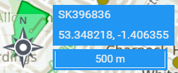
In the example below, coordinates are shown in latitude longitude as well as a British National Grid six figure grid reference of the current 100m square.
Configuration
The Mouse Position tool has the following settings.
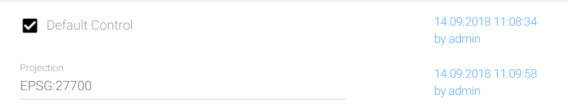
Default Control
When enabled, displays the mouse position in decimal degrees (latitude longitude / EPSG:4326).
Projection
When specified, also displays the mouse position in the specified projection (specified using EPSG code). Please note that when EPSG:27700 (British National Grid) is specified, only the six figure grid reference will be displayed rather than full British National Grid coordinates.